Friday, June 27, 2008

Hope, AK

We left Valdez on Tuesday morning and headed for the Kenai Peninsula. It was too long a drive for one day, so we stopped at Finger Lake State Park for one night just outside of Palmer. Then on Wednesday we came from Palmer through Anchorage and south on the Seward Highway. The highway follows the Turnagain Arm which is a body of water off the Cook Inlet south of Anchorage. Our first destination on the Kenai Penisula was the small community of Hope, AK. It is on the south side of the Turnagain Peninsula. We were camped at Seaview Café and Bar RV Park - right on the water with Resurrection Creek coming into Turnagain Arm right out our front window. It is 16 miles off the Seward Highway to Hope, which is at the end of the road.


Thursday was a rainy day. We ate breakfast at Tito’s Discovery Café and then rode some of the back roads and streets checking out the area. The rest of the community has a couple of dirt streets with a Post Office, museum, library, gift shop, and a restaurant. No gas stations. Most of the houses are really old looking - some are log houses. We figure there’s a lot of history here.

The salmon are expected to start running up Resurrection Creek any day now - all the locals (and lots of visitors, too) keep driving down by the creek (and our campsite) looking to see if the salmon have showed up yet.


Today (Friday) we left Hope and headed on further south down the Kenai Peninsula - destination Seward, AK.

Tuesday, June 24, 2008

Valdez, AK

Valdez (pronounced "Val-deez") is a neat place - a small town on the inlet from the Prince William Sound with snow covered mountains all around. On Saturday we rode all around the area (which isn’t too big). The drive along the opposite shore of the inlet out to the Alaska Pipeline Terminal was very beautiful.


Saw lot of “good” birds - Pigeon Guillemots, Harlequin Ducks, Black-legged Kittwakes, and a Red-throated Loon. Also, Bald Eagles are plentiful - you can see them soaring around and perching in the trees and on power poles.


Sunday was a rainy day. After church we visited a couple of gift shops and took another drive over to the pipeline terminal.

Yesterday (Monday) was a fabulous day - we took a 9 hour boat ride with the Stan Stephens Glacier and Wildlife Cruises. The tour boat was the Valdez Spirit - an 83 foot twin-hull catamaran with two 800 horsepower diesel engines. Unbelievable vessel - 20 knots smooth as glass. We had a window seat in the inside top deck, but spent a lot of time on the outer deck.


From Valdez, we went out into the Prince William Sound through the narrows into the Valdez Arm.


As we cruised along, there was lots of wildlife to see. Sea Otters were plentiful.


The first big attraction was the Columbia Glacier. The boat weaved it’s way through all the ice burgs to get close.


After a great chicken alfredo over rice lunch we cruised around to Mears Glacier.


On both the outbound and inbound legs of the cruise we saw several Humpback Whales.


We saw lots of birds, Horned and Tufted Puffins, Marbled Murrelets, Mew Gulls,, and Black-legged Kittiwakes. We also passed a colony of Stellar Sea Lions.


Horned Puffin


This was a fantastic cruise - one of the things we were really looking forward to doing in Alaska!! What a wonderful experience.

Saturday, June 21, 2008

Glennallen to Valdez, Alaska

Thursday we left Tok and headed for Valdez. We didn’t want to drive the
whole way in one day, so after about 140 miles we stopped for the night
near Glennallen at the Dry Creek State Recreation Area. Although the road had been re-surfaced and was pretty good for part of the way, there was still a lot of it that was rough - frost heaves and the roller coaster ride of 30-40 mph. We followed the Wrangell Mountains which were off to the west and saw snow covered Mt. Sanford that was over 16,000 feet! We also saw a moose with a calf - came right out into the road in front of us.

Yesterday (Friday) we drove the Richardson Highway from Glennallen to Valdez. We keep wondering how the scenery can keep getting better. The road was still roller coaster for a lot of the 120 miles, but the slower ride allows more time to “ooh and ahh”! Here’s a couple of pictures just riding down the road.


We stopped at Worthington Glacier State Recreation Area and walked the paved paths to the base of the glacier. One of our “life” birds for this trip is a Mew Gull.


After Worthington Glacier we crossed Thompson Pass at 2675 feet and then descended a 7.5 mile grade down to Keystone Canyon. The canyon floor is at 400-500 feet elevation and the high canyon walls on either side of the road are covered with the most beautiful green vegetation imaginable with waterfalls all along the way. Spectacular!


From the canyon the landscape flattened out through a broad valley all the way into Valdez at sea level. This small town is on the Prince William Sound and we have a campsite right on the water. Across the inlet is the terminating point of the Trans Alaska Pipeline and the back drop is more of the beautiful snow covered mountains. A really beautiful place - we’re going to be here several days.


Our campsite


The view out our back window

Wednesday, June 18, 2008

Tok, Alaska

We spent Father’s Day driving the third leg of the Alaska Highway - and we still didn’t get there. We left Watson Lake, drove 372 miles, and got to Haines Junction - still in the Yukon Territory. At least the road was much better than the day before - was able to do 50-55 mph most of the way. There was one stretch under construction for about 8 miles and was gravel - slow going there. Also, for 25 miles or so out of Whitehorse the road was pretty rough. Other than those minor stretches, no complaints. The scenery still remains awesome - high snow capped mountains in the distance and beautiful lakes all along. Teslin Lake is something like 86 miles long and we followed it for many of those miles. Here are a couple more pictures of driving the Alaska Highway.


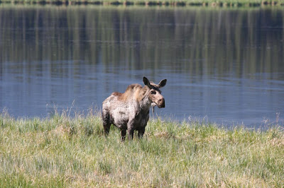
We had to spend an extra day in Haines Junction - had a flat tire on the motorhome and it took all day to get someone out to fix it. We left there yesterday (Tuesday) and finished the Yukon portion of the Alaska Highway. The road along this portion of the highway is still very scenic, but is the roughest we have seen. Did see some wildlife - several Bald Eagles and a moose.


We crossed into Alaska about 1:00 PM and made it through the US customs with no trouble. Had to set our watches and clocks back another hour - we’re now on Alaska Time - 4 hours behind Eastern.


Well, we thought the highway across the last part of the Yukon Territory was rough, but once into Alaska it proved to be just as bad - and in some spots worse. With all the frost heaves, it was like riding a roller-coaster and we were only able to drive 30-40 mph for the last 92 miles to Tok, AK. In addition to the rough roads, there was also some serious road construction in one spot.


However, bad roads and all, the scenery is still spectacular!!


We made it to Tok (pronounced like Token without the ’en’) and found a campsite for a couple of nights. Hopefully, now that “WE’RE HERE!!”, we can slow down a little from the long drives and poke around up here awhile.

Today we checked out the Visitor’s Center here in Tok that covers all of Alaska. Got lots of good material to help plan the rest of our Alaska Adventure. Tomorrow we’ll head toward Valdez.

Saturday, June 14, 2008

Alaska Highway - Watson Lake, YK

Yesterday, Friday the 13th we headed out of Dawson Creek and north on the Alaska Highway. The first part of the drive was through a more populated area of farm country and was a sunny drive to Fort St. John. Once past this point the landscape became all forested on both sides of the highway. Also, a few miles north of Fort St. John it clouded up and started to rain. We climbed in elevation to a little over 3800 feet and the rain became heavy snow for a long way - in fact was starting to accumulate on the roadway.


Then we went back down to a lower elevation and it became all rain again - and rained pretty much the rest of the drive. We stopped after 285 miles at Ft. Nelson, BC for the night and it rained for pretty much the rest of the afternoon.

As we were driving along in the rain, we saw 2 or 3 cars stopped beside the road ahead of us. First thought was they had spied a moose - there are moose warning signs all along. I slowed down to see what it was, but by the time we did see it, I was too far by to stop. It was two Grizzly Bears in the edge of the woods by the highway. LaVerne was mad at me for the rest of the day because I didn’t get stopped in time (and backing up in the motorhome with the Jeep back there is a no-no).

Today we left Ft. Nelson, BC with much better weather - a mix of clouds and sun all day with a couple of light showers along the way. Not far out of Ft. Nelson we left the sparsely populated areas and headed into the northern portion of the Canadian Rockies which extend up in to northern British Columbia and the Yukon Territory. We started at an elevation of around 1300 feet and proceeded to climb up and go down for a couple of hundred miles. We crossed a couple of summits that were around 4600 feet, then down into beautiful river valleys at around 2500 feet. Really fantastic scenery. Here’s some pictures --


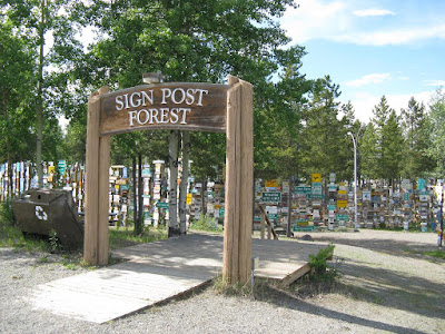
Along the way we saw some wildlife - although not as much as we’d hoped for. We saw deer, several buffalo, and 5 separate Black Bears, but no Caribou or sheep. The second leg of the Alaska Highway today was 325 miles and we stopped for the night at Watson Lake, YK. This is where the world famous “Sign Post Forest” is located - they have hundreds of posts with thousands of signs that people from all over the world have put up. After getting our campsite set up for the night went into town and checked it out and put up our sign!


Tomorrow the adventure continues!

Thursday, June 12, 2008

Dawson Creek, BC

Yesterday, Wednesday, we left Jasper, Alberta and drove northwest 330 miles to Dawson Creek, British Columbia. What a great drive - TCH 16 to Hinton, then Hwy 40 north to Grand Prairie, and then Hwy 43 and Hwy 2 west to Dawson Creek. We saw a good bit of wildlife along the way - deer, elk, a moose right by the road, and a black bear.

We checked into the Mile “0” RV Park for two nights. We needed a day of R&R, plus we needed to do some domestic chores - laundry, grocery shopping, motorhome maintenance, etc.

Dawson Creek is where the Alaska Highway starts and it is about 1500 miles from here to Fairbanks, AK - a little over 1100 miles to the Alaska border. The United States obtained the right-of-way from Canada and built the Alaska Highway during WWII and then turned it over to Canada after the war. Construction began in March of 1942 and finished a little over 7 months later in October. Originally it was called the ALCAN (Alaska-Canada) Highway, but somewhere along the way it was changed to the Alaska Highway. Everybody has to take a picture at the beginning of the highway.


Tomorrow we are headed “North to Alaska”!!!

Tuesday, June 10, 2008

Jasper, Alberta

After another day of sightseeing in Banff, we left Saturday morning and moved about 45 miles north to Lake Louise. What a neat place! There is a small village, but the main attraction is the lake itself which is a few miles up a mountain road. The lake, a beautiful turquoise color, is surrounded on three sides by the tall snow-covered mountains with the huge Fairmont Chateau Hotel at one end of the lake. The view from the hotel looking across the lake with the surrounding mountains is awesome.


We also checked out another popular spot here - Lake Moraine. Not quite as scenic as Lake Louise, but definitely not too shabby!


The second day while we were staying at Lake Louise we drove across the Continental Divide into British Columbia and into Yoho National Park. One of the main scenic spots there is another of the beautiful lakes with a hotel alongside - Emerald Lake. It rivaled Lake Louise for beauty and was not nearly as crowded.


In addition to the sightseeing, we are also doing a lot of birding. At Emerald Lake we got a good look at a Red-necked Grebe (a "life" bird for us), and also at another scenic overlook we saw some Harlequin Ducks.

Here's a picture of the Red-necked Grebe


Yesterday (Monday) we left Lake Louise and drove north to Jasper on Hwy 93 - the Ice Fields Parkway. It was about 145 miles and very scenic all the way. We saw lots of wildlife, including a female Grizzly Bear with a last year’s cub, plus a herd of big horn sheep.


Today we did more sightseeing around Jasper - lots of beautiful, scenic lakes with names like Annette, Patricia, Mildred, Edith, Pyramid, and Beauvert. We also drove back down Hwy 93 a few miles and went to Athabasca Falls.


We’re through with this part of Canada now and tomorrow will be headed to Dawson City, BC where the Alaska Highway begins. Alaska here we come!

Friday, June 6, 2008

Banff, Alberta

Wednesday we left Cochrane and had a short scenic drive on the Trans Canada Hwy 1 to Banff -- did I say scenic?? I meant SCENIC -- WOW!

We started out in more of the flat to rolling farm and ranch lands, but we could see the rise of the majestic, snow-covered Canadian Rockies in front of us - and they kept getting closer and closer and even more majestic as we neared them. Basically Hwy 1 follows the Bow River Valley along the valley floor all the way into Banff and right in among the mountains - I mean right into the middle of them.


We arrived and checked into our campground around 11:30. The scenery is awesome. Right out our door and through the windows we have a fantastic view of the river valley with the tall snow-covered mountains all around. God did some of his best work here.


We went into downtown Banff to check it out. It’s really a trendy tourist town with all kinds of lodging, shopping, eating, etc. Reminded us of an upscale Gatlinburg, TN. I guess the snow-covered mountains all around here are a little more eye-catching than the Smokies around Gatlinburg.

Thursday we went birding and looking at all the scenic places around Banff. We drove out to Lake Minnewanka and Two Jack Lake. Here’s a couple of pictures:


Then we drove 10 or 12 miles on Hwy 1A (Bow River Parkway) toward Lake Louise that is a scenic 2-lane road that parallels Trans Canada Hwy 1 (the 4-lane). Along Hwy 1A there are lots of pullouts for scenic views. In addition to all the scenery, we also saw lots of birds, a moose, an elk, a coyote, and several Mule Deer.

Here’s another picture on Hwy 1 coming back into Banff from the north side.


Today was another day of birding and sightseeing and tomorrow it’s on to Lake Louise.